The Invisible System That Guides the World
How GPS became one of the most valuable public investments in history

GPS is so embedded in daily life that most people don’t even notice it. And with more than four billion people using it daily — for free — the extraordinary story behind it remains largely untold. At its most basic, GPS is a timing system consisting of more than 30 satellites that orbit the earth in Medium Earth Orbit (MEO), roughly 12,500 miles from Earth. The satellites broadcast a precise radio signal continuously. Since radio waves travel at a constant speed (the speed of light), your device measures the time it takes for the signal to travel, and converts that to distance. The system uses at least 4 satellites at a time to precisely pinpoint your position, three of those to home in on your exact position and the fourth to correct for the imprecision of your device’s internal clock.
The intellectual roots of the GPS system can be traced to a series of efforts to address the US military’s urgent need to track satellites — a need that became more urgent following the Soviet Union’s surprise launch of Sputnik in 1957. The earliest efforts were led by Roger Easton of the Naval Research Laboratory, who developed the first satellite tracking system. This system included a number of ground-based receivers deployed along the east coast of the US and into South America, all positioned along the 75th meridian longitude. When a satellite passed overhead, this network of receivers picked up the broadcast signal and could measure the precise angle of passage, which allowed for the calculation of the satellite’s orbit. This system, called Minitrack, was online in time to track Sputnik 1 and 2.
One shortcoming of the Minitrack system was that it required a broadcast signal from the satellite — and under Easton’s leadership and funding from the Defense Advanced Research Projects Agency (DARPA), the Naval Space Surveillance System was launched. The goal of this program was to develop a system that would allow the tracking of any object (broadcast or no broadcast) orbiting Earth. Once that system became operational, the inversion — using satellites to track ground-based receivers — became a conceptual possibility.
The US began launching satellites into MEO in 1967, as part of the Timation Program, also directed by Easton. By the time Timation 1 was launched, Easton had been thinking about and developing the component systems required for an orbital tracking system for 25 years. Two critical components to his thinking at this time were the need for a “passive” system — meaning the broadcast signal was sent continuously, and did not require a response from the receiving object — and the need for an atomic clock that is capable of keeping extremely accurate time.
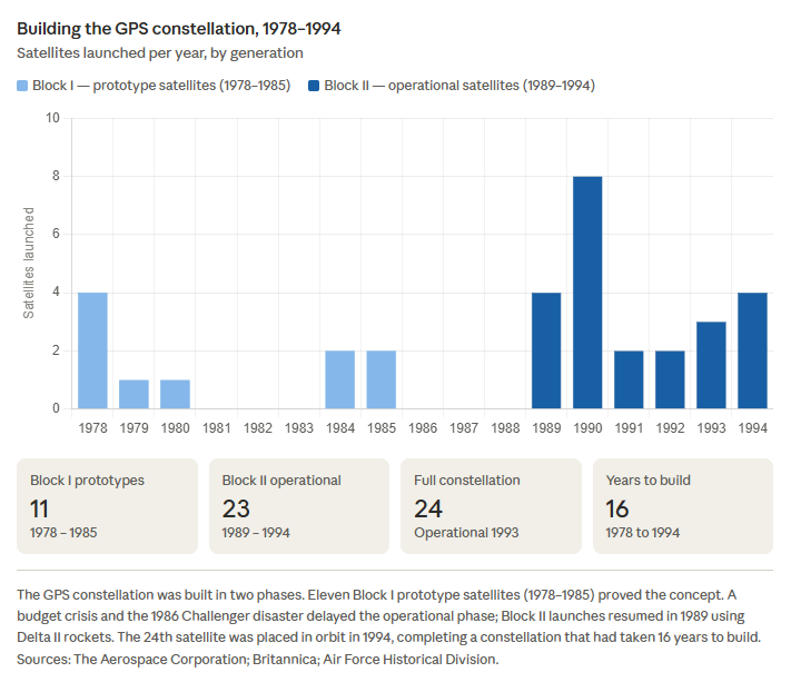
The formal GPS program, which was called NAVSTAR, was launched in 1973 by the US Department of Defense, with the Air Force designated to lead it. NAVSTAR used many of Easton’s concepts in the design of the program. The first GPS satellite was launched in 1978 from Vandenberg Air Force Base in California, and through the next sixteen years 24 satellites were launched to build out the full constellation. The program was declared fully operational by the Air Force in 1995.1
However, developing a navigation system of this complexity required more than just satellites — it also required building a mathematical model that allowed the system to accurately translate satellite signals into a precise location on Earth’s surface. This is much more complicated than it might seem — the Earth is not an exact sphere, nor even a slightly flattened ellipsoid as it is sometimes represented. The model needed to account for the Earth’s uneven surface, as well as gravity, the tides, and other forces that distort the surface. And this work was led by Gladys West at the Naval Surface Warfare Center in Dahlgren, Virginia. A Black mathematician who was born into poverty and raised in rural Virginia, West graduated as valedictorian of her high school and went on to earn two mathematics degrees from Virginia State University before arriving in Dahlgren in 1956. She was only the second Black woman and one of only four Black employees who worked at the facility at the time she was hired. From the mid-1970s through the 1980s, she led the team that programmed the IBM 7030 Stretch computer to build the precise model that took into account the physical irregularities and surface structure of the Earth. Without her model, the satellites would not have been able to precisely pinpoint the location of the receiver of the signal — your device.
While the GPS system was fully operational by the mid-1990s, its usefulness as a tool for determining the precise location of a receiver was limited by design — a policy called Selective Availability. The Department of Defense had hobbled the system to prevent adversaries from using it to pinpoint the location of US forces. In its degraded state, the system could pinpoint a location to within roughly 100 meters. In May of 2000, President Clinton directed the immediate discontinuance of Selective Availability, which improved the accuracy of the GPS system to within about 5 meters and paved the way for the expanded commercial use of the system.
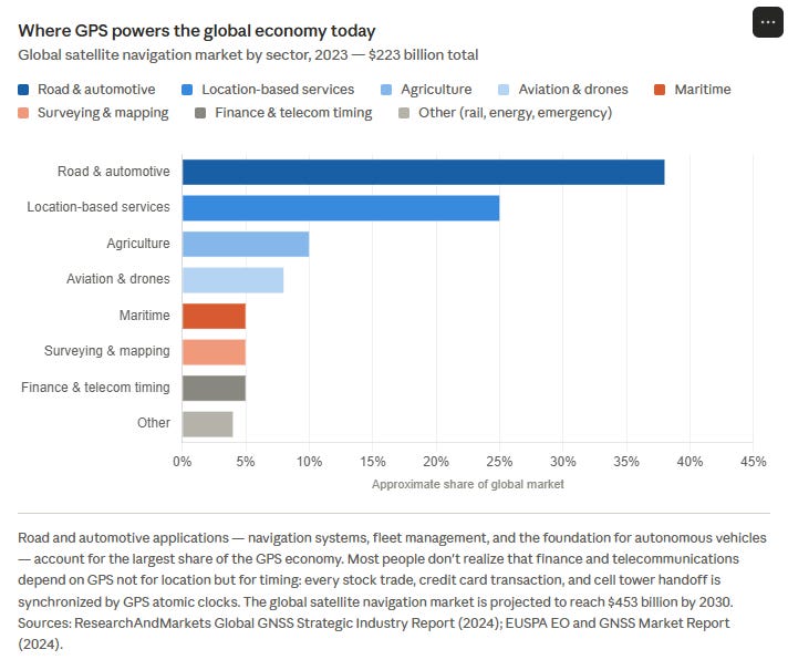
Since the early 2000s, there has been an explosion of economic growth tied directly to the availability of the GPS system. For example, precision farming using GPS allows farmers to apply water, fertilizer, and pesticides to within inches of their needed location, greatly improving effectiveness and reducing waste. Importantly, these technologies are also being widely applied by farmers in developing economies. Your in-car navigation system, package tracking services on Amazon, and emergency services all benefit immensely from the use of GPS. Its availability — free to anyone with a receiver — has allowed an entire generation of businesses to be built around it. Uber and DoorDash are among the most familiar examples.
Which brings us back to the fundamental contribution made by Gladys West, who passed away in January of this year. She was not recognized for her contributions until later in her life. In 2018, twenty years after she retired, the Virginia General Assembly formally recognized her contributions — when she was 87 years old. Other awards followed, including the Prince Philip Medal from the Royal Academy of Engineering in 2021, and her inclusion on the Department of Transportation Walk of Fame in Washington DC in 2022. Her model continues to guide the world.
References: